In the realm of construction and civil engineering, the importance of understanding subsurface utilities cannot be overstated. As projects become increasingly complex, the need for effective subsurface utility solutions has grown exponentially. These solutions not only enhance safety but also ensure that projects are executed efficiently, minimising delays and unforeseen costs. This article delves into the various aspects of subsurface utility solutions, highlighting their significance and the technologies involved.
The Importance of Subsurface Utility Mapping
Subsurface utility mapping is the process of identifying and documenting the location of underground utilities such as water, gas, electricity, and telecommunications. Accurate mapping is crucial for several reasons.
Risk Mitigation
One of the primary benefits of subsurface utility mapping is the mitigation of risks associated with utility strikes. Striking a utility line during excavation can lead to severe consequences, including injury, service disruption, and costly repairs. By employing advanced mapping techniques, project managers can significantly reduce the likelihood of such incidents.
Cost Efficiency
Inaccurate utility information can lead to project delays and budget overruns. By investing in thorough subsurface utility mapping, organisations can avoid the costs associated with unexpected utility relocations and repairs. This proactive approach not only saves money but also enhances the overall efficiency of the project.
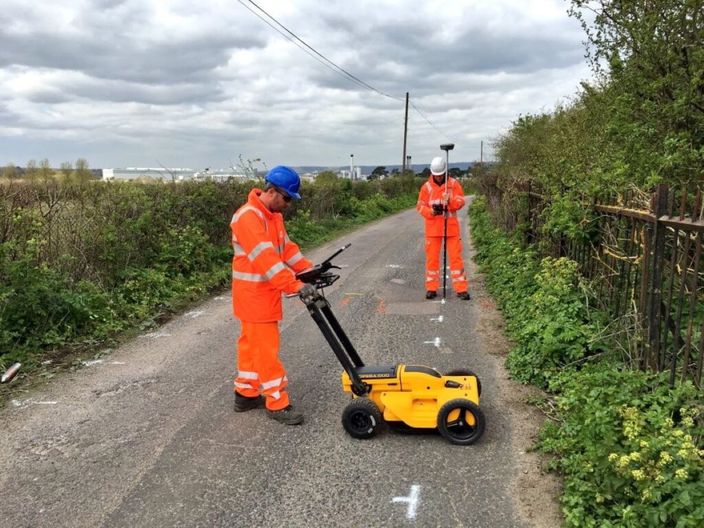
Furthermore, the integration of modern technologies such as Ground Penetrating Radar (GPR) and Geographic Information Systems (GIS) has revolutionised the field of subsurface utility mapping. These tools allow for a more precise and comprehensive understanding of the underground landscape, enabling engineers and contractors to visualise the utility networks in three dimensions. This level of detail is invaluable, particularly in urban environments where utilities are densely packed and often interwoven, making traditional mapping methods insufficient.
Additionally, the importance of collaboration among various stakeholders cannot be overstated. Effective subsurface utility mapping requires input from utility companies, engineers, and contractors to ensure that all relevant data is collected and shared. This collaborative approach not only fosters a culture of safety but also promotes transparency and accountability throughout the project lifecycle. By working together, these parties can create a more reliable and informative mapping process, ultimately leading to smoother project execution and enhanced public safety.
Technologies in Subsurface Utility Solutions
The landscape of subsurface utility solutions has evolved dramatically with advancements in technology. Various methods are now available to accurately locate and map underground utilities.
Ground Penetrating Radar (GPR)
Ground Penetrating Radar (GPR) is a non-destructive method that uses radar pulses to image the subsurface. This technology is particularly effective in identifying the presence of utilities, as well as determining their depth and material composition. GPR is widely used due to its accuracy and efficiency, allowing for quick data collection without the need for extensive excavation. Furthermore, GPR can be employed in a variety of environments, including urban areas where space is limited and in rural settings where traditional methods may be less effective. The versatility of GPR makes it an invaluable tool for engineers and contractors, as it can also detect other subsurface anomalies such as voids or changes in soil density, which may indicate potential hazards.
Electromagnetic Induction
Electromagnetic induction is another widely used technique in subsurface utility detection. This method involves sending an electromagnetic signal through the ground, which then reflects off metallic utilities. The reflected signals are captured and analysed to determine the location and depth of the utilities. This technology is especially useful for locating buried metallic pipes and cables. In addition, electromagnetic induction can be employed in conjunction with other methods, such as GPR, to enhance the accuracy of utility detection. By using multiple technologies, surveyors can cross-verify findings, thereby reducing the risk of errors that could lead to costly damage during excavation. The ability to pinpoint the exact location of utilities not only improves safety but also streamlines project timelines, allowing for more efficient planning and execution.
Utility Location Services
Professional utility location services combine various technologies and methodologies to provide comprehensive subsurface utility solutions. These services typically include site surveys, utility mapping, and the creation of detailed reports that outline the findings. By leveraging the expertise of professionals, project managers can ensure that they have the most accurate and up-to-date information regarding subsurface utilities. Moreover, these services often incorporate advanced software tools that facilitate the integration of utility data into Geographic Information Systems (GIS). This integration allows for better visualisation and analysis of subsurface utilities, enabling stakeholders to make informed decisions regarding infrastructure development and maintenance. As cities continue to grow and evolve, the importance of accurate utility mapping cannot be overstated, as it plays a crucial role in urban planning and the sustainable development of public works.
Implementing Subsurface Utility Solutions
Successfully implementing subsurface utility solutions requires careful planning and coordination among various stakeholders. It is essential to integrate these solutions into the overall project workflow.
Collaboration with Stakeholders
Collaboration among project stakeholders, including engineers, contractors, and utility providers, is vital for the successful implementation of subsurface utility solutions. Early engagement with these parties can facilitate the sharing of critical information, ensuring that everyone is on the same page regarding the location and condition of subsurface utilities. This collaborative effort not only helps to mitigate risks associated with unexpected utility strikes but also fosters a sense of shared responsibility. Regular meetings and workshops can be beneficial, allowing stakeholders to discuss potential challenges and develop strategies to address them, ultimately leading to a more cohesive project execution.
Integration into Project Planning
Incorporating subsurface utility solutions into the project planning phase is essential for maximising their benefits. By identifying utility locations early in the design process, engineers can make informed decisions that minimise disruptions and enhance safety. This proactive approach not only streamlines the construction process but also fosters a culture of safety on site. Furthermore, the use of advanced technologies such as Geographic Information Systems (GIS) and 3D modelling can significantly improve the accuracy of utility mapping. These tools enable project teams to visualise subsurface conditions more effectively, allowing for better risk assessment and resource allocation. As a result, projects can proceed with greater confidence, reducing the likelihood of costly delays and ensuring that safety protocols are adhered to throughout the construction phase. You may like to visit https://grateoutdoorsolutions.com/cable-locating-services-101-avoiding-risks-under-the-surface/ to get more about Cable Locating Services 101: Avoiding Risks Under the Surface.
Case Studies: Successful Implementation
Examining real-world examples of successful subsurface utility solutions can provide valuable insights into their effectiveness and application. Several projects have demonstrated the benefits of thorough utility mapping and detection.
Urban Redevelopment Project
In a recent urban redevelopment project in Sydney, comprehensive subsurface utility mapping was conducted prior to excavation. By employing GPR and electromagnetic induction techniques, the project team was able to accurately identify and document the location of various utilities, including water mains and electrical cables. This information allowed for precise planning and execution, resulting in a significant reduction in project delays and costs. Furthermore, the use of these advanced technologies not only enhanced safety for workers on site but also ensured that the integrity of existing infrastructure was maintained, thereby preventing costly repairs and potential service interruptions for local residents.
The success of this project has sparked interest from other municipalities looking to adopt similar methodologies. Local authorities are now considering the implementation of mandatory utility mapping for all major construction projects, recognising that the long-term benefits far outweigh the initial investment. This shift in policy could lead to a new standard in urban planning, where the integration of technology and infrastructure management becomes paramount in fostering sustainable development.
Highway Expansion Project
Another notable example is a highway expansion project in Melbourne, where utility strikes had previously caused extensive delays. By integrating advanced subsurface utility solutions into the planning phase, the project team was able to identify potential conflicts early on. This proactive approach enabled them to reroute utilities as needed, ensuring a smooth construction process and minimising disruptions to traffic. Additionally, the collaboration between engineers and utility providers was enhanced, fostering a spirit of cooperation that is often lacking in large-scale projects.
The positive outcomes of this highway expansion have encouraged further investment in subsurface utility engineering across the region. Stakeholders have begun to recognise the importance of utilising cutting-edge technology not just for immediate project needs but also for long-term infrastructure resilience. As a result, there is a growing emphasis on training and upskilling the workforce in these advanced techniques, ensuring that future projects can benefit from the lessons learned in Melbourne and beyond.
Challenges in Subsurface Utility Solutions
Despite the numerous benefits of subsurface utility solutions, several challenges persist. Understanding these challenges is crucial for developing effective strategies to overcome them.
Data Accuracy and Reliability
One of the primary challenges in subsurface utility mapping is ensuring the accuracy and reliability of the data collected. Variations in soil conditions, utility materials, and the age of existing infrastructure can all impact the effectiveness of detection methods. Continuous advancements in technology and methodologies are essential for improving data accuracy.
Regulatory Compliance
Another challenge faced by project teams is navigating the complex regulatory landscape surrounding subsurface utilities. Different jurisdictions may have varying requirements for utility mapping and reporting. Ensuring compliance with these regulations can be time-consuming and may require additional resources.

The Future of Subsurface Utility Solutions
The future of subsurface utility solutions looks promising, with ongoing advancements in technology and methodologies. As the construction industry continues to evolve, the demand for accurate and efficient utility mapping will only increase.
Emerging Technologies
Emerging technologies, such as artificial intelligence and machine learning, are beginning to play a role in subsurface utility solutions. These technologies can enhance data analysis and interpretation, leading to more accurate and efficient mapping processes. As these technologies mature, they are likely to revolutionise the way subsurface utilities are managed.
Sustainability and Environmental Considerations
As sustainability becomes a more pressing concern in the construction industry, subsurface utility solutions will need to adapt to address environmental considerations. Developing methods that minimise environmental impact while ensuring accurate utility mapping will be essential for future projects.
Conclusion
Subsurface utility solutions are an integral part of safe and efficient project execution in the construction and civil engineering sectors. By investing in accurate utility mapping and detection technologies, organisations can mitigate risks, improve cost efficiency, and enhance overall project outcomes. As the industry continues to evolve, embracing emerging technologies and fostering collaboration among stakeholders will be key to overcoming challenges and ensuring successful project execution.
In a world where infrastructure is constantly changing and evolving, the importance of subsurface utility solutions cannot be underestimated. By prioritising these solutions, project managers can pave the way for safer, more efficient, and more sustainable construction practices.